

The Davies, Route 1.
Vihren #17 and Hvoinati #18.
There is no particular order that you should climb The Davies. Route 1, for most people, has to be the highest and most impressive mountain in Pirin. Over the next 20 or 30 posts we aim to describe our favourite routes to top of the Pirin mountains. Please understand these are not the best, the easiest, the most beautiful or any other superlative you care to mention. The routes we describe here are the ones we go back to time after time because we like them. If you prefer a different way please share on our Facebook page
 The majority of people will follow the obvious route from Vihren hut straight up the south face to the summit and back the way they came. This is the shortest, easiest and in our opinion least splendid route.
Route 1 has an extra kilometre or 2 of walking and 100 or 200 meters more ascent but it is well worth making the extra effort.
 Start at Bunderitsa hut. There is a spring in the garden here where you can fill your water bottles, this is a very dry route so take extra water. The start of the path is just up hill from the main building. There is a sign here marking the official start of the trail (it is hard to find) The sign reads “premkata”.
The path climbs steeply through mature pine forest and clearings are filled with lush vegetation. This is one of the official National Park trails and as such is well marked and well maintained. Green and white stripes painted on trees and rocks mark the path all the way to the pass.
Crossing the treeline you enter alpine pasture with the occasional patch of “Kleck”. This indomitable bush will feature often in your adventures in Pirin. Kleck is Pinus Mugo a hardy pine bush that thrives in the Balkans. It is possible to travel through Kleck but possible ….. not easy. Always try to go round patches of Kleck where possible. Over the years we have spent many many hours trapped in webs of Kleck and have learned to hate it with a passion.
 Up to your right a few venerable pines keep a determined grip on the ridge. You are now in Alpine pasture proper, tongues of scree lick through the pasture, ridges of rock dominate the horizon. You will cross your first short section of rough ground and scree before the the landscape opens up.
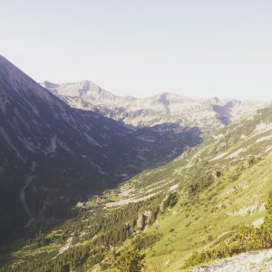
At around 2200m the path drops into the amphitheatre of Little Kazana . This large open bowl of grass and wild flowers is beautiful in the spring and offers your eyes their last balm of green for a few hours. Looming up from Little Kazana you will get your first view of the awesome splendour of Vihren’s north face. This near vertical wall of cast limestone is a truly impressive sight. The horizon up and left is the Djamdjiev ridge. Locally a very famous route up Vihren with some climbing sections.

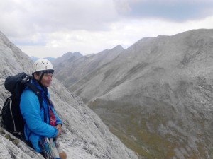
Crossing the grassy bowl of Little Kazana you will start a steep zig zag climb, up the rocky gully and over the ridge into the main bowl of Kazana at 2400m. Here you see the 500m north face of Vihren in it’s entirety. There are a dozen or so routes up this beauty most of which are best attempted in the winter when the rock is frozen together! We have tried 3 of them in the summer and they make for interesting climbing on unstable rock.
The main bowl of Kazana is filled most of the year with snow and often wild goats. They have become very relaxed around humans expecting easy pickings from tourists. Often you can get to within meters of them before they are spooked and run off. Pirin eagles are starting to come back and can sometimes been seen here enjoying the cliffs!
You are now about 1/2 way up so push on! This is one of the finest view points in Pirin and it is tempting to loiter, the sun is getting hotter and the trail is bare from here to the summit. I normally try and get the majority of the climbing done before it gets too hot.
The Path out of Kazana is steep and rocky. The sandy surface on the steeper sections can be annoying so step carefully, the gully isn’t long and quickly you will be out into the grassy meadows between Vihren and Kutelo. It is worth wandering over to the Vihren side of the meadows for some lovely views into Kazana from above. It’s a short potter up the to main pass “Premkata” between Vihren and Kutelo.
 At Premkata you have fantastic views West to Macedonia, South to Greece, North towards Plovdiv and East all along the main back bone of Pirin . Pause let it all sink in, Breathe, feel the magic and stride on. The summit is only step away! the crown of Vihren is very distinct from here and you really get a wonderful sense of the forces involved in building mountain ranges.
Follow the path up the increasingly steep and eroded zig zags until you come to the main band of rock that makes up the summit. Here a chain has been installed to assist the faint hearted. Scramble up about 25m until the path turns left. At this point turn right away from the main trail and head for a gap in the ridge. It is a difficult scramble for some but easy enough even if you have no experience. The views are spectacular and well worth it. After less than 5 minutes you will arrive on the summit!
The Trail down is shockingly eroded and surprisingly hard on the legs. Once you are back onto grass the walking becomes easier. The trail is almost due south until you come to the lowest point between Vihren and Hvoinati. Carry on off the main trail up the slabby mess of rock that is the summit ridge and soon you will be on the summit of Hvoinati. The views south south east to Moratovo, Ribno and Dulgo lakes is lovely.
 Follow the summit ridge 150m due east and descend north towards the main tourist trail. Keep to the right of the ridge as the left side holds more scree. Once you are on the main trail it is under 2 hours walk until you reach Vihren hut.
We love this route. As you will see over the next few years Di and I differ slightly on timings. Di is a gentleman of advanced years and shockingly fit whilst I am an over weight recently ex-smoker! At the end of each route I will publish two times as below. One is the Davies route time, this is the number of hours a reasonably fit person would take to walk it not including their rest stops. The second is how long I normally spend on the hill doing the route including lunch, naps, rests and photo oportunities!
The Davies, Route 1. Di Time 5 hours, James Time 6.5 hours.
Written by:-
Di Davies and James Hughes
