
The Davies, Route 9.
Peak#26 2504m, Peak #27 2506m, Peak #28 2508m, Spanopolski Chukar #29 2576m, Karaulite #30 2533m, Banderishki Chukar #31 2738m, Peak #32 2500m, Bashliyski Chukar #38 2670m.
The Davies, Route 9. This is a long and arduous day with lots of bouldering that will test even the strongest legs. Be sure to pick a good day. Any adverse weather will turn a hard walk into a dangerous one! One early autumn day the Banderishki boulders were still covered in ice and I was forced to retreat. In July a hailstorm turned the mountains wintery and we quickly descended for an early beer! There is an escape route to the north about half way round the circus which I will describe in due course.
The Davies, Route 9 is a hard day, take food and water, allow at least 10 hours. This is hard walking over difficult ground. If the weather turns run away! The route can be cut into two days by using the escape route as the exit from the first day and the entry for the second day
From Vihren hut follow the marked trail towards Sinanitsa hut (blue trail / yellow trail). The path follows the valley floor towards Muratov peak with the river on your left. As you depart from the river you will climb up past the pretty Muratov lake and arrive at Banderitsa Porter. At the pass you will leave the marked trail. Turn left here heading south east. There is a trail that ascends gradually over easy ground to the start of the boulder work which leads to the first unnamed peak, #26 2504m. Keep to the ridge line for the best fun or follow the faint path to the south that runs along under the south side of the ridge. 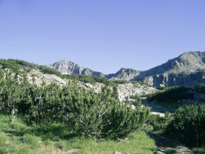
Hike up and down a little until the until a steep drop leads down to a very sharp notch in the ridge line. Follow the path round to the right (south). After 75m or so turn sharply up to the left (north). A steep vegetated and gravely slope leads to the second un named peak #28 2508.
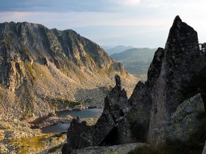
Continue east along the ridge for another 200m, turn right here (south) to reach the col before Spanopolski Chukar. This is a fine little excursion to a wonderful view point. Spanopolski Chukar #29 2576m, stands alone over looking the rolling hills to the south of Pirin. Do not linger too long as there is still a lot of work to be done!
Retrace your steps back to the col and then contour round to join the main ridge. The climb up Donchovi Karaulite #30 2633m is short and uneventful, descend the east ridge of Doncho to an open col. Here there is a large obvious cairn ( pile of stones) that marks the north bound escape route. You are now about half way round in terms of distance but the hardest part is to come.
Traverse around a minor top (not a peak). There is a lot of Kleck (dwarf pine) that looks impassable but there is a path over and through it which is quicker than dropping down to the right (south). The push up to Banderishki Chukar #31 2738m feels endless, the boulders are large and hard work! At and near the main summit the boulders are massive slabs with impressive chasms between them. This is tough going! 
From the summit descend almost straight south down through more boulders to the col and then up the north slope of Bashliyski Chukar #38 2670m. It looks close, it isn’t ! The final climb is up and over, around and under a mass of boulders and klek. A real sting in the tail at the end of a long day.The summit is at the far end of the ridge and offers fantastic views.
Retrace your steps to the col between Banderishki and Bashliyski, contour back to the ridge line. The unnamed peak #32 2500m is on the east shoulder of Banderishki chukar. The going is difficult. A short distance down the ridge from #32 a descent can be made directly north. Make for a small group of pools/lakes below the peak, just beyond the lakes you will find the main red trail from Vihren to Tevno. Join this path heading north west back to Vihren hut.
Breaking the day in two. Escape route.
The Davies, Route 9. Remember we mentioned that cairn at the col after Donchovi Karaulite? If you wish to break this trip into two descend north here. The first part of the decent is steep and the semi vegetated slope is slipery with sand and loose stones. Go carefully. After a drop of about 25m and slope eases, Descend vegetated then bouldered slopes to the little lakes that you could see from above. Pass the lakes on the west side (lakes on your right) following the stream that drains the lakes. The descent is again steep and boulder filled for another 25m. Now break right through a steep vegetated slope towards a flat area filled with giant boulders. Descend steeply again through large boulders heading towards the cliff that borders the stream that feeds Ribno lake . Follow this stream down to the lake. Skirt the lake until you join the main path back to Vihren hut.
To continue your circuit retrace your steps on the second day up past the lake and onto the ridge at the cairn.
N.B. #27 2506m.
The Davies, Route 9. Unnamed peak #27. This peak looks eminently doable on the map and feels like it should be included in on this route. Sadly the route is just too long to add another diversion off the main trail.
I feel it is worth doing this little mountain as a single day trip from Vihren hut, the route is pretty simple. From Muratovo lake head in almost a straight line towards the summit. Skirting left (east) of the klek at the base of the summit you will find a steep rock filled gully that leads directly to the summit. Descend east down to Ribno lake and the main path back to Vihren hut.
This is a short day, maybe 4 hours. Importantly it is a great introduction to hiking off piste. If you have never walked off a marked trail I would suggest this as your first wild adventure! The area is relatively easy to navigate and there is zero chance of getting dangerously lost. The route finding and scrambling are all at entry levels of difficulty. 
Di Davies
