

The Davies, Tevno Hut 2512m.
Momin Dvor #51 2714m , Kralev Dvor #52 2680m , Demirkapiiski Chukar #61 2648m , Valyavishki Chukar I #50 2664m, Valyavishki Chukar II #48 2564m, Begovishki Preval #60 2533m.
The Davies, Tevno Hut. The Davies is a challenge, a game if you like, to climb all the peaks in Pirin over 2500m. Most of the route descriptions we will publish here will start at a road and ultimately end at a road as well. There is one region of Pirin however that is the exception to this rule. That region is the area around Tevno hut. This chapter will be all about Tevno, the peaks surrounding the hut and the routes to and from the it. 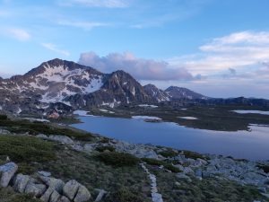
Tevno is a fantastic little hut, sat on a shelf of flat land next to a lake the hut offers shelter right in the heart of national park Pirin. The Hut and lake are high (2512m) and remote (4 hours walk from civilisation) but Valia and Ivan who run the hut offer a welcome and level of care that are well beyond the call of duty. The food is simple hearty fayre made with love and the hut is warm dry and clean. I love staying at Tevno there is a special place in my heart for this wonderful spot. I really hope you get the chance to visit and I am sure you will fall as deeply in love with Tevno as I have.
Getting to Tevno.
There are 4 main routes to Tevno. The red trail from Vihren. The blue trail from Damianitsa. The green (then Blue) trail from Bez Bog. The blue (then yellow) trail from Begovitsa. The red trail from Vihren is about 8 hours walk and all the others are about 4 hours. I will not go into great detail of the routes as they will be explained elsewhere in this guide. 
Vihren hut to Tevno, 8 hours. This is a long walk but awesome. You can easily bag 6 or 7 of The Davies along the way! The trail is well marked and mostly follows the main ridge line of Pirin offering great views all the way. There is little or no water on this trail so take plenty.
Damianitsa hut to Tevno, 4 or 6 hours. you will need to find a local with a 4×4 to drop you at Damianitsa hut or allow another 2 hours walk from the end of the metalled road to the hut. Even if you can’t get a lift this is a lovely walk. The trail follows the river from deep within the forest up though alpine meadows, past high alpine lakes and into the mountains proper. 
Bez Bog to Tevno, 4 hours. Please not the opening and closing times of the chair lift at Bez Bog they change through the seasons so check their website or facebook page. From the Bez Bog hut you roll through mostly high alpine country past Popovo lake on the green trail. Just after the Popovo the trail splits, the main trail carries on due south over the u shaped pass and the trail to Tevno climbs up into a side valley full of pretty little lakes. The trail here is marked with blue trail markers and climbs through fields of boulders.
Begovitsa to Tevno, 4 hours. The Begovitsa hut is just inside the forest, sheltered and well fitted out with good rooms, showers and food. Relatively easily accessible this hut is seriously underrated and a bit of a gem! The walk to Tevno is through a wide grassy valley which in the spring is full of flowers. The mountains above Begovitsa offer a spectacular backdrop to a beautiful walk.
 The Peaks around Tevno
Assuming you leave in the morning you will arrive at Tevno in time for lunch. Except if you are coming from Vihren. I normally have a bowl of soup and a salad, dump my bag and either set off for an afternoon stroll or have a sleep in a meadow! There are 3 easy peaks close to the hut, Momin Dvor #51 2714m , Valyavishki Chukar I #50 2664m, Valyavishki Chukar II #48 2564m. One 90 minutes away, Begovishki Preval #60 2533m and two that you should probably bag on your way to or from the hut Kralev Dvor #52 2680m , Demirkapiiski Chukar #61 2648m.
From east to west the three peaks north of Tevno hut are Momin Dvor #51 2714m , Valyavishki Chukar I #50 2664m, Valyavishki Chukar II #48 2564m. After lunch at the hut Follow the main trail east to the Kralev Dvor left gate (Kralev Dvorska leva porta). This is the blue trail that leads back to Bez Bog hut. At the pass turn left and follow the steep ridge up to the summit of Momin Dvor it is about 150m of ascent over rough ground and fields of boulders near the summit. The path though unmarked is clear and easy to follow as it hugs the ridge line.
From the summit head west down the ridge towards the saddle just above Tevno hut. Again the path is unmarked but clear enough. At the saddle there is a cross and a tv aerial. from here it is less than a 100m up an easy clear path to Valyavishki Chukar I. From Valyavishki Chukar I the trail continues along the ridge over rough broken ground to Valyavishki Chukar II. It is a difficult descent from Valyavishki Chukar II either down the steep winter route west to Mozgoviska porter or straight down throught the boulders to the lake side. There is a chain to help you down the winter route but be warned it is steep and sandy. Some people re trace their steps back to the saddle above the hut. all threee descents are about the same time wise.
To hike all three peaks would take you about 3 hours at a gentle pace and offers a great opportunity for photos.
 To the south of Tevno Hut about 90 minutes walk away is Begovishki Vrah (Begovishki Preval) . This little peak poking up in the middle of a steep spur looks intimidating from the north. Its north facing cliffs are near vertical and made of broken rock. Thankfully the south side of the ridge is gently sloping grassy meadows.
From the hut follow the trail pass the toilets and washing area, it is not clearly marked but heads almost due south towards the lake at the foot of Kamenitsa. Crossing the stream at the foot of Kamenitsa the yellow trail markers become clearer. Follow the trail through the boulders around the west shoulder of Kamenitsa. The trail meets climbs up through a grassy slope to the pass where it joins the blue trail from Begovitsa. At the top of the pass turn right (west) and follow the faint trail along the ridge line. The trail doesn’t follow the true ridge line all the way to Begovishki Vrah. it drops down into the grasses whenever there are difficult rocky sections on the ridge. Just before the peak it drops about 15m down below the rocks and then climbs again to the summit between the rocks.
Retrace your steps back to Tevno hut. From Tevno to Begovishki Vrah and back should take you about 3 or 4 hours if you go gently. A local guide tried to tell me he did it in 90 minutes but I think 3 or 4 hours is more realistic for mere mortals like us!
If you are coming to Tevno from Bez Bog it is worth taking a little detour up Demirkapiiski Chukar #61 2648m and Kralev Dvor #52 2680m. Up and down Demirkapiiski Chukar will add about 90 minutes to your trip. From Bez Bog you pass Popovo lake and then follow the blue trail up passed Momini / Samodivski lakes. After the lakes the trail enters an area of boulders and Demirkapiiski Chukar is above you to the south. There is no clearly marked trail to the summit but if you hack up through the grassy field straight towards the summit you will be ok. The summit is an interesting little problem when viewed from below, sheer rock with an inviting chimney leading to the summit. It looks difficult, in reality there is a nice easy path to the right of the summit along the east west ridge. 
From Demirkapiiski Chukar descend back to the blue path and up through the boulders to the pass. We normally leave our bags at the pass and scramble up the 75m of ascent to the summit of Kralev Dvor it is a short steep climb but it’s only 20 to 30 minutes to the summit and very satisfying! Descend back down the same ridge, grab your bags and head on to Tevno!
