

The Davies, Route 2.
Djano #80, Chengel Chal #81, Demir Chal #82, Yazunov Vrah #83, Kornishki Vrah #84, Hleven #85, Kadiev Vrah #90.
As a contrast to Route 1, I thought route 2 should be one of least visited corners of Pirin. I have a profound love for the extremities of National Park Pirin. These rolling hills of cropped grass are rarely visited. They are so hard to get to that they have a sacrosanct aura to them . I went to Hleven #85 this weekend so it’s just chance that it is route 2. The trail head was full of the weekend crowds heading to Popovo lake for a picnic. A few more intrepid souls were climbing Djano #80 and a couple of over loaded Israelis were heading south to Melnik. With each step the crowds thinned and as I passed Djano I was alone. The next 24 hours were as close to the old gods as anyone would wish to be.

The Davies, Route 2 starts from the splendid relic that is the Dobrinishtay ski lift. Built under communism this lift looks like your worst health and safety nightmare. However long ago it was built, it was built well and built strong. Now after many many years of loving care she is still running like a dream. The team who run Dobrinishtay are a perfect example of Bulgarian hospitality, rough and ready they are always laughing and joking, friendly and caring.
The journey to Bez Bog Hut is about 40 minutes through a mixed corridor of pine and beech forest. As you start the second section of the lift the forest gives way to a sea of Klek that rolls over the landscape as far as you can see. The path skirts around the west bank of the lake beneath the north face of Bez Bog #62. On the far side of the lake you climb for 15 minutes up a heavily eroded section to the pass overlooking the lake, hut, sea of Klek and the road down to Greece. 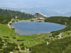
Once you cross the pass the trail is wide and well maintained. the landscape opens up and you get fine views of Djangal#87 with her mighty fortress walls, Popovo lake , Sivria#78 and Djano#80. It’s a splendid walk down to Popovo lake the trail winds through meadows of wild flowers, crossings of stepping stones over little streams huge skies and views rolling off into blue hills make for a picturesque walk. Happy groups of picnic-ers heading for the lake lend a Sunday afternoon feel to this section.
 Once you arrive at Popovo lake the vast majority of walkers will stop on the banks of the lake and unleash mountains of tomatoes, sausage, bread and cheese. The Bulgarian picnic is a serious affair and will take many hours . If you head round the west side of the lake there are a few nice swimming spots next to rocky outcrops and at the most southerly point a grassy meadow where the little river feeds the lake. About 200m up the river is the junction. The right hand fork goes to Tevno the left heads south. I normally stop here for elevenses.
Follow the left hand fork which criss-crosses the stream up the valley towards the pass. The trail gets steeper and steeper until it forks again straight on it follows the rocky stream over the pass and down to Greece, left it cuts faintly into the wide grassy expanse that is the north west face of Djano. This is your last chance to get any water so fill your boots. The stream is clean and ice cold you wont get a chance to fill up again until you are back here tomorrow so drink deep and fill all your bottles. I’m sure there is a proper trail up this hill but I never find it and I think the majority of people just wander up randomly. It’s a good 40 minute pull up to the summit and hard work in the mid day sun. The summit of Djano is a destination point for a lot of hikers. The views are spectacular with many many lakes visible in every direction. 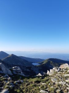
This is a magical spot, you can feel the wilderness calling. In every direction the wild rules. The odd herder calling to his flocks, a tourist in the distance, far far off villages are brown scratches in the endless forests. This is the domain of the old gods, bear, wolf, chamois, bugs and birds. 10 minutes scramble down the ridge onto the rocky exposed pass and you are totally removed from humanity. The first 500m of the trail is difficult going, the ridge is a mess of huge broken rocks and you’ll need to use your hands to get through. After the exertion of crossing the ridge take a few moments to feel this landscape.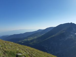
The route is pretty simple from here on, Follow the ridge south. At some points it might skirt left or right of the ridge but for the vast majority of the way it runs true along the ridge.
Chengel Chal#81, Demir Chal#82, Yazunov Vrah #83, Kornishki Vrah #84, Hleven#85 The first 4 peaks are of classic Pirin smashed rock sharp jagged broken summits, harsh on the ankles and soles, barren dead places, baked dry by the sun, fields of scree plunging down on both sides towards the distant greens of the valley. It’s a good 3 hour march along the ridge each peak involving a 30 or 40 minute climb the sun and the sterility of the landscape play games on your mind. The silence and vast openness of the landscape draw your thoughts away from the mundane. My body has settled into the routine of long distance walking, legs work on auto pilot, my pace changing according to the terrain but my heart rate and breathing are as constant as if I were meditating. 
This, for me is the joy of hiking, the landscape rolling past, the wind and the sun on my skin, my brain slows down and the buzz of modern life quietens to a litany of observation. The odd flower leaps up and touches your eye, the lushness of a patch of soil where last weeks rain has finally seeped out. Huge ants grafting away, herds of cattle clonking down in the valley, birds riding the wind that ripples the lakes surface.
There is no up and down at this pace your body settles into the landscape if you allow it. You can flow with the countryside, no step tiring you out, no climb or descent being too much. Fighting to race up or down the slopes lengthening your pace to eat up the flat sections, leaning into the climbs. None of this works, you can’t conquer mountains, you can’t dominate them, they will not bend to your will, all you will do is break yourself against them. So roll on.
 The jagged spine of Kornishki Vrah gives way to a totally different landscape. Hleven is like the Tors of my mountains in the west country. A torn sheet of rolling grass reveals the old bones of well worn rock. This is the last mountain in eastern Pirin and looks totally different from all the others, older and more feminine. The country falls away on all sides row upon row of smaller and smaller hills tuning blue with distance.
This is the place to camp, if you have brought enough food and water stop here. The views are perfect for both sunset and sun rise. The turf is soft and flat the old rocks offer shelter from the wind. 
For me no chance to rest. I had little water and no food, I had underestimated the walk and now had to return as far as possible. The next flat bit of land good for camping is 3 hours north of Hleven so I turned my back on Greece and set off. The miles disappear easily with an empty mind and soon I was settled in on a shelf of flat ground near the summit of Chengel chal .
 The next morning I took a small detour along Kadiev Rid to bag Kadiev Vrah#90 and then back to Djano. The descent from Djano to the river and on to Popovo lake is a gentle return to civilisation. Following the main trail back towards Bez Bog you can either join the crowds climbing over the ridge or drop off the main trail and head for the shepherds hut and around the ridge. This trail isn’t marked but it is the only right turn off the main trail. It;s marked on most maps so you should be able to find it with a little bit of cartographic literacy.
Bez Bog can be a bit of a shock after a couple of days away from civilisation. especially on a Sunday afternoon! Crowds of day trippers pack the shoreline eating and drinking sunbathing and laughing! It’s a happy sight but very different from the peace and solitude of Hleven.
Authors note:- Mountains existed long before man decided to name them and mountains will exist long after our civilisation has become dust. Bulgaria has been through some significant socio-political changes in the last 150 years. Under the Turkish occupation the mountains had Turkish names, under the Russian/Communist regime communist names and now New Bulgarian names. All this time locals have had their own names for certain peaks and places important to them. This has led to some significant confusion as to what the mountains are called. I have tried to use the most common names for peaks but in some cases this is impossible. In such cases I have written the name of the peak in red. For example Academica#16 this mountain does not have a name. but at 2681m is a significant peak. People who are not from Bansko call this mountain Cherna Mogila, but Cherna Mogila is a small hill in front of Academica#16. This is one of the classic mistakes of mountain cartography. The map maker sat on the valley floor points up into the hills and asks a local shepherd what is the name of that. The shepherd thinks he is pointing to the hill with a name not the nameless peak and there starts confusion!!!! I have christened it Adcademica after the hotel and ski lift at the foot of the mountain and I hope this name holds as it feels about right. Please forgive me my arrogance in giving peaks names, I claim no right in doing so it is more a matter of embarrassment at not knowing and a dislike of blank spaces.
Written by:-
James Hughes and Di Davies
